Greater Victoria residents now have a new resource to help them be better prepared for tsunamis, thanks to a partnership between the Capital Regional District and the provincial government.
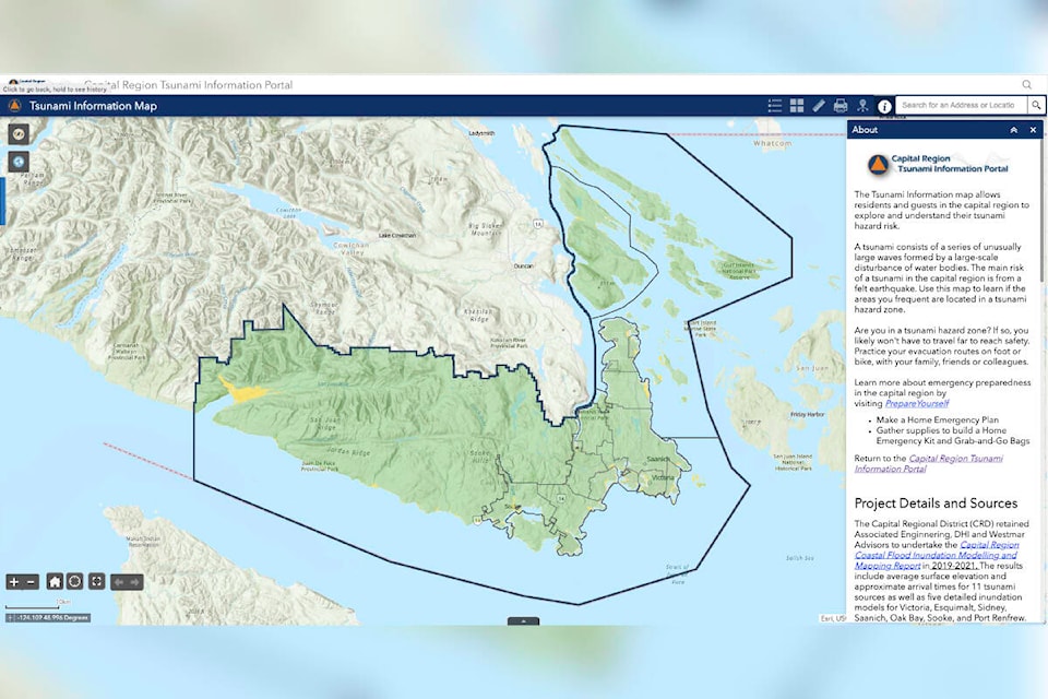
The Capital Region Tsunami Information Portal was officially launched on Tuesday (Sept. 20). The portal provides a map of the region which allows residents and visitors to see which areas are in a hazard zone in the event of a tsunami, and even allows specific addresses to be looked up.
“The Capital Region is at risk to tsunami hazards from several potential sources, fortunately, most of the coastline has a limited risk, and most of the area is at low risk to no risk of a tsunami, but it is important for people to know where the tsunami zones in the region are located,” said Ben Arril with GeoBC.
“The tsunami information portal map is a really cool tool that helps people visualize and learn about tsunami hazards.”
Arril said the goal of the portal is to help residents be prepared now, so they know what to do in the event of a tsunami. For example, he said residents who discover they live in a low-risk area, indicated by green colouring on the map, would be encouraged to remain in place during a tsunami as they would be safe and it would keep escape routes clear for those in a hazard zone – yellow on the map – to move to safer ground.
The portal was created by GeoBC using coastal flood modelling developed by Associated Engineering, DHI and Westmar Advisors with funding from the federal and provincial national disaster mitigation program, and was initiated by the regional emergency management partnership.
The base modelling was created by the University of Delaware and is available as a public, open-source data set which has been used by many organizations. It was tested against other models and compared to known historical tsunami data to ensure it is as accurate as possible when used in the portal.
It includes 30-metre resolution 3D models of both undersea and land terrain for the entire region, with four-metre resolution models for specific areas, including Port Renfrew, Sooke, Victoria, Esquimalt, and Sidney.
The portal is available online at maps.prepareyourself.ca.
READ MORE: Tsunami risk from Sooke to Sidney
READ MORE: Company creates shelter-in-place tsunami solutions as B.C. sits in risk zone
@JSamanski
justin.samanski-langille@goldstreamgazette.com
Like us on Facebook and follow us on Twitter.